I heard through the grapevine that a bunch of 8-10 year old kids in the U.K. published in a prestigious journal, led by their teacher and a research scientist. The topic was bees and my interest lies not in the publishing part but in the science and kids part, especially treating science like a game or puzzle. The kids formulated the questions and hypothesis and constructed the game and analyzed the results ... even writing up the manuscript. As the essay stated, which accompanied the article, the kids were proud of what they had learned and wanted to share that knowledge. Now that is some good science education.
http://rsbl.royalsocietypublishing.org/content/early/2010/12/18/rsbl.2010.1056.full?sid=c43f1415-9fbc-4f1b-94b3-51866e5edbd2
Tuesday, December 28, 2010
Saturday, December 25, 2010
Scales of uncertainty
The latest fuss in meteorological circles has focused rather intently on the Storm of Christmas, then the day after, and now the day after the day after Christmas storm. The storm has been "delayed" by 2 days over the course of the last week, and has shifted position numerous times in the forecast (gonna miss far to the east, bounce back to the west for a hit). We call this behavior uncertainty.
So what is uncertainty? "not confirmed", "still undecided", a "lack in confidence"
In modeling terms, the forecast solution has not yet converged. Our current capabilities, however, are quite robust at short range, meaning we expect the solution (over many initialization cycles) to converge. This time period is usually between 48 and 72 hours depending on the modeling system, the scale of the features that need to be resolved well, and the overall scale of the dynamical system which we seek to predict.
Over the years, despite many advances in satellite data, data assimilation systems, and numerical models and their increasingly sophisticated methods ... we still need to wait for the disturbances to enter the well instrumented radiosonde network*. Alas this too can be deceiving as was the case for the Surprise snowstorm of January 2000. You see a classic nor'easter can have origins from the Pacific Northwest which travels in amplified flow towards the gulf coast. The system itself may never leave the well instrumented but the warm gulf, cool temperatures aloft, and strong wind shear may foster convection ... thunderstorms ... or organized noise. This noise can then feedback from the large scale to the small scale ... outside the network and remain outside the network as the coastal low forms and deepens as it travels up the coast.
So, you can see how a "converged" solution of where the storm will be, can help us have confidence on predicting the other aspects of the storms. But uncertainty remains in where the precipitation will be, what precipitation type will fall, and for how long.
This uncertainty about snowfall placement and amount is very similar to the summer forecasting of thunderstorms. We may have a converged solution of the larger scale details but the smaller scale details can have a large effect on where, when, which storms will form and how severe they might be.
This where the art of forecasting kicks in. Where the analog experience of forecasters contributes. Knowing how they were fooled last time, or how they picked up on certain observed details which caused them to do better than the models. The forecaster has the ability to understand these scales of uncertainty. Only in the last few years have methods been developed, like the Ensemble Kalman Filter, which can show us where the uncertainty is for a specified region at 3,5,7 day lead time. In fact the Winter Weather Reconaissance program is designed to use these methods, then collect data in the uncertain regions to see how that can change the forecast and its uncertainty!
Wednesday, December 1, 2010
Turkey and Construction
I like to read blogs and watch TED talks. So naturally, staying home with a fever allows me to catch up from Thanksgiving travel.
Tuned In had a great perspective on Turkey and Thanksgiving. How often do we cook turkey aside from Thanksgiving or order turkey from a restaurant? I never considered this take on turkey. It was ingrained. I need to enhance my turkey perspective since i know that turkeys are now bred for Thanksgiving. Is this a sustainable practice?
Earlier I watched a builder (Dan Phillips) discuss the philosophical underpinning behind modern construction techniques/practices. he said there are two groups of people for which I am sure the spellings are completely wrong: Dionysians and Appelonians. The former demands perfection and elegance, brand new materials, constructed perfectly, no imperfections anywhere. This view of modern construction produces a lot of waste. Waste that this builder uses to build imperfect houses. And they are interesting! Clearly I am a practical Appelonian who can live with flaws. Things only need to be fixed when they cease to function. When they cease to function you harvest the parts, or break them, to create new parts. His closing statement said that we have put vanity at the foundation of our lives. And this is not sustainable.
This was a fascinating talk on many levels. So why blog about Turkey and Philosophical Construction Practices? Both are ingrained into our perspective of how things are. Right Now. As a society we need to be concerned with how we want the future to unfold. We want our perspective to be rich, dense, and broad. This is how we make our traditions sustainable. We need to be aware of the consequences or at least put some forethought into what the consequences might be. Our founding fathers did and stated this. They wrote it down in many ways and acknowledged the imperfections both in the document itself and themselves. That is pretty profound and very rich in perspective.
We are failing in this regard. Our perspective is about wants in the here and now. We all need to get back to needs. And perhaps it starts with changing our perspective. Unless you try to serve ham at Thanksgiving.
Tuesday, November 16, 2010
Enabling students to cheat
http://chronicle.com/article/The-Shadow-Scholar/125329/
Right from the horses mouth. Someone who wants to be a writer so bad they will choose to write papers deceptively. But this person asks us to overlook this minor indiscretion in favor of the bigger picture. The bigger picture is WHY students request this service:
An education system that somehow failed?
A lazy student who couldn't be bothered to do any work?
Or rather a student who did more work prepping the cheater to be successful so they could be free of this hassle?
"It is my hope that this essay will initiate such a conversation. As for me, I'm planning to retire. I'm tired of helping you make your students look competent."
Thanks. Conversation initiated. I am glad you are retiring. I also hope your business has not been passed on.
I don't believe you were ever asked by teachers to make our students look competent. Rather we expected to our students to WANT to be competent. That want is motivation. But that alone is not enough. At some point you have to DO. You have to strive to achieve that which you are not capable of doing now, or capable of doing without help.
Weask beg our students to seek help when they need it. The best professors always offer help and guidance. We have not enabled them like you have. We have demanded improvement, self motivation, commitment, and LEARNING. As I demonstrated in one class, knowledge is not served on a silver platter for the taking. It is acquired, over time, with work and practice.
You gave them an alternative. An easier alternative albeit expensive. You enabled them to be lazy.
I have no qualms with pointing fingers at our education system. Part of it is institutional involving "teaching to the test". Part of it may be the teachers (some old that don't care, some young that don't know how, some that are not passionate, and some that have no choice but to be a glorified teen-sitter). part of it may be generational (tried and true teaching methods may no longer be working in the age of internet "knowledge" ... "I can just look that up why do I need to remember that fact").
Convenient that he can not remember the clients' name. Perhaps revealing who these people are might help the "conversation" you have started. It might help to explain why some of them are in leadership roles who can't lead, bosses who are idiots, or prevent real thinkers from advancing into roles where they can be most useful.
It only gets worse when you contribute to the problem and then leave it for someone else to clean up. Thanks for the legacy. Release the names of your clients. Post it on Google. Thesis titles too please. I know those are easy to look up.
The generational divide is causing more problems than I know how to fathom. The problems are non-linear and cumbersome and difficult to divide and conquer as is. Enabling is a symptom of this. Your lack of perspective and moral consequences will be remembered. Most importantly, don't be confused. You are no scholar. A scholar would be concerned with ethics because the process and the work are important.
Right from the horses mouth. Someone who wants to be a writer so bad they will choose to write papers deceptively. But this person asks us to overlook this minor indiscretion in favor of the bigger picture. The bigger picture is WHY students request this service:
An education system that somehow failed?
A lazy student who couldn't be bothered to do any work?
Or rather a student who did more work prepping the cheater to be successful so they could be free of this hassle?
"It is my hope that this essay will initiate such a conversation. As for me, I'm planning to retire. I'm tired of helping you make your students look competent."
Thanks. Conversation initiated. I am glad you are retiring. I also hope your business has not been passed on.
I don't believe you were ever asked by teachers to make our students look competent. Rather we expected to our students to WANT to be competent. That want is motivation. But that alone is not enough. At some point you have to DO. You have to strive to achieve that which you are not capable of doing now, or capable of doing without help.
We
You gave them an alternative. An easier alternative albeit expensive. You enabled them to be lazy.
I have no qualms with pointing fingers at our education system. Part of it is institutional involving "teaching to the test". Part of it may be the teachers (some old that don't care, some young that don't know how, some that are not passionate, and some that have no choice but to be a glorified teen-sitter). part of it may be generational (tried and true teaching methods may no longer be working in the age of internet "knowledge" ... "I can just look that up why do I need to remember that fact").
Convenient that he can not remember the clients' name. Perhaps revealing who these people are might help the "conversation" you have started. It might help to explain why some of them are in leadership roles who can't lead, bosses who are idiots, or prevent real thinkers from advancing into roles where they can be most useful.
It only gets worse when you contribute to the problem and then leave it for someone else to clean up. Thanks for the legacy. Release the names of your clients. Post it on Google. Thesis titles too please. I know those are easy to look up.
The generational divide is causing more problems than I know how to fathom. The problems are non-linear and cumbersome and difficult to divide and conquer as is. Enabling is a symptom of this. Your lack of perspective and moral consequences will be remembered. Most importantly, don't be confused. You are no scholar. A scholar would be concerned with ethics because the process and the work are important.
Tuesday, November 9, 2010
Changing thinking
I have been recently obsessed with TED talks:
From Elizabeth Gilberts' nurturing creativity to Jill Bolte Taylors' stroke of insight to Malcolm Gladwells' tale of Spaghetti Sauce.
http://www.ted.com/talks?orderedby=MOSTFAVORITED
They all have a unique perspective that transforms the way they view the current culture of thinking. In essence, they adopt the opposite point of view of the currently held belief (for lack of a better term). This isn't fair to Jill since she had no choice and neither was it fair for Elizabeth since she was pestered into a corner.
The people that make the biggest gains in thinking seem to be able to critically observe what we do now and evaluate if that model fits now. Observe is the operative word. Like a good joke by a comedian. "We" get so used to doing things one way that we start choosing to do things incrementally in that same way. (Yin and Yang) Until someone looks around and changes the game instead of changing the rules.
Which leads my strange mind into the last TED talk about what leads to success. Which if you need a link you really aren't that motivated to hear the talk. Being smart was not one of the 8. So I decided to be clever:
Good Ideas Persist. Focused Work Serves. Push your Passion.
Passion Pushes Good, Focused Ideas with Persistent Work to Serve.
So, take a step or two back and look around.
UPDATE:
My line of thinking did not include saying incremental science is bad. rather, incrementally, the science improved to the extent that it could before it required a new direction. Often it seems these transformations in thinking are natural ... but "we" have no way of comparing these transformations to the changes in thinking which went nowhere.
Monday, November 1, 2010
From hurricane to weak storm: Tomas


Tomas weakened rapidly as "shear" tore it apart. It became obvious this wasnt upper level shear but rather midlevel shear as the mid-level vortex decoupled from the low-level vortex. Animations of this period show a very strong band of convection to the southeast actually develop its own outflow signature. This area of convection persisted even as Tomas' CDO decayed to reveal the low level swirl this morning. The upper level shear probably did change as Tomas excellent outflow was virtually absent in the southern quadrant. Deep convection refired late in the morning but was pretty ragged and the HH aircraft found Tomas significantly weakened and disorganized.
hard to know what may have actually happened, but I am stuck wondering what role the SE area of convection played in Tomas demise, more specifically how that area of convection established its own outflow and how that interacted with Tomas. Also, what was the decoupling mechanism and how vertically confined was it to shear the vortex apart and only briefly stall deep convection?
Anywho, this is not my area of expertise. I am interested in where Tomas goes and how it interacts with the cutoff cyclone in the Gulf by Saturday.
The GFS takes the upper level low into the gulf where it rapidly weakens in 18 hours, though the effects of the low may be felt very far south as a cold surge. Though cold might be a relative term. The GFS is rampant with parameterized convective rainfall and that could be one mechanism for the destruction of PV aloft. The other mechanism for not leaving the cutoff over the gulf is another disturbance on the dynamic tropopause that crosses the ridge and helps keep moving things along.
Either way how things play out with Tomas and the cutoff low is rather interesting from a predictability standpoint, for all the individual elements (TC, cutoff low, cold surge, and heavy rainfall for Florida, Cuba and Haiti). Expect some impacts from this entanglement. In the meantime I need to look closely at the GFS ensemble.
Sunday, October 24, 2010
Impressive Jet streak off the Pac coast
The new radiosondes with GPS winds really have made a difference, though there has been little talk or even research on this. The difference has really been the availability of upper tropospheric winds in strong jets. I did a little work in this area to look into where and when the old radiosondes would lose the wind data. I will have to dig it up at some point.
The inspiration for this post came as I checked my email this evening and was made aware that the RUC model failed in its initial attempt at a forecast today. The reason was a strong jet entering the Pac Coast. Here is the 250 hPa map:

And the sounding for MFR:
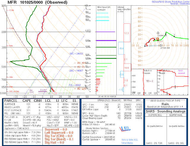
167 knots or 86 m s-1! And there was still wind data all the way to 7 hPa! These speeds are not too much higher than this morning with 157 and 149 knots at SLE and MFR.
Upon further reflection though, October 500 hPa temperatures at -25 C seem a little extreme. And thats not even in the core of the extratropical cyclone! Maybe it will come ashore tomorrow near UIL.
Portland has thunderstorms in the forecast and there is lightning along the coast.
I will have to dig into how extreme these temperatures are for the Pacific Coast in October.
UPDATE: 195 knots from MFR this morning!

Saturday, October 23, 2010
Interesting Null tornado event

Yet, despite having supercell like qualities they faded into obscurity after 2-3 hours.

Missing from the closest observed sounding (taken AFTER the storms and somewhat well removed from the INITIAL area, but was later just south of an area of again small storms) was a layer of steep lapse rates, and a cap. Seemingly the near isothermal area around 500 hPa was a CAPE robber.
This sounding is intriguing only when we look at the overall 12 hour changes in the area of interest. The 850, 700, 500 temperatures had cooled at OUN. At FWD, 850 and 700 T was down 1 degree C, but the 500 T had warmed by 3 C while at 601 T had cooled by 2.6C! The upper low which showed a jetlet rounding the base of the trough at 500 hPa had weakened by 5 m s-1.
Water vapor imagery doesn't show this 500-600 presumed frontal zone as the upper levels were quite moist. It appears a subtropical jet/ shortwave was influencing the action over Texas. Maybe this "front" was a small scale circulation. I found it about the same pressure level, same potential temperature at DRT 12 hours prior albeit weaker.
Nothing at the surface really jumps out. Dew points held in the 59-62 F range in advance of the storms. Something mesoscale was happening for sure but its difficult to understand what. Model simulations anyone?
Sidenote: I did happen to see a wave-like feature that had passed over the CI area just prior to CI on IR imagery that interacted with some small storms in OK. Easily seen on Visible as cirrus.
Monday, October 18, 2010
Comments on Climate Change adaptation
http://freakonomics.blogs.nytimes.com/2010/10/18/matthew-kahn-answers-your-climatopolis-questions/
A couple of comments:
1. "Most people live in cities". This may be True but there are alot of people who live on the coastline.
2. "If the world had 1 bald guy there would be no Rogaine." I don't think that one follows logically from the other. rather, there was a need to invent Rogaine because 1 guy didn't like being bald or figured out bald people don't like being bald. This is capitalism. Not adaptation. Adaptation would have been the bald guy figuring out that some chicks dig dudes with no hair or wearing a nice hat. After all Rogaine was a solution to a problem, whereas adaptation is learning to live with the problem or (more my way of thinking) not treating your lack of hair as a problem.
3. "Free market capitalism will protect us from climate change." The free market built up our coastlines while hurricanes went slightly dormant for a 20 year spell. And when they raged back alot of people lost their homes on the coastline ... see point 1.
4. "People update their probabilities as new information arises."And Monkeys fly out of my ass... People are generally good at assessing their risk. People are generally bad about acting timely on that risk because they misjudge based on imperfect information. Its why people in New Orleans and East decided to stay put. They had good intel. BIG storm surge, powerful hurricane, strong winds. They had heard this and the evacuation orders. Some still stayed citing previous experience with hurricanes. Some 1700 people died. They updated their probabilities but we will never know how much weight they assigned to those probabilities.
5. I like the eternal optimist: "Educate the citizens about heat waves." Perhaps you are more likely to survive if you can afford, and consequently purchase an air conditioner. But first, after I update my probabilities, I realize that a heat wave just happened and wont return for at least a while so i will wait. I will wait because my first priority will be to put food on the table instead of waiting 1,2,5,10 years before the next heat wave hits.
6. "In Climatopolis, I assume that such a dramatic event would occur gradually." Rarely has drought been gradual. It is sudden and lasts for a while. The impacts are slow because first you realize you are in a drought after the drought has started (reminds me of a recession, or a post-recession). Then you realize you have find some method of rationing which is gradual and increases as the length of the drought increases. Afterall predicting how, where, when, and why a drought is relieved is no easy business.
But this is the point. These opinions make certain assumptions about the rapidity of discrete events. They also make assumptions about the rapidity of innovation to discrete events. Maybe you can take Einstein as an example: from mathematics failure to patent guy teaching himself mathematics. That took time and experience and a whole host of other factors. With climate there may not be sudden achievable advances with which to adapt. rather we will have to know not just our next set of circumstances but the ones after that. We will have adapted in some ways, over time, but we are not built to continually adapt (henceforth accelerated adaptation).
Certainly the community (academic, industrial, manufacturing) we have built is adapting and it shows. Bio-diesel from corn, algae or whatever. But that is one maybe two steps forward but no less realizable on a global scale. The ideas will come out, with this I agree. But, will the time it takes to realize these ideas come faster and faster as the need, not just arises, but indeed accelerates?
This is why climate change science needs to be done. We need to understand the possible outcomes, or impacts of regional climate change. People will have to be making decisions in advance, with limited information. Only this will apply to those who have the means to afford those decisions in advance. Some of us live month to month, day to day and simply cannot afford to make decisions without some sense of certainty (picking up and moving to a new area without the means to support oneself with a job all based on uncertain information with no timetable of when "climate change" will occur.
A couple of comments:
1. "Most people live in cities". This may be True but there are alot of people who live on the coastline.
2. "If the world had 1 bald guy there would be no Rogaine." I don't think that one follows logically from the other. rather, there was a need to invent Rogaine because 1 guy didn't like being bald or figured out bald people don't like being bald. This is capitalism. Not adaptation. Adaptation would have been the bald guy figuring out that some chicks dig dudes with no hair or wearing a nice hat. After all Rogaine was a solution to a problem, whereas adaptation is learning to live with the problem or (more my way of thinking) not treating your lack of hair as a problem.
3. "Free market capitalism will protect us from climate change." The free market built up our coastlines while hurricanes went slightly dormant for a 20 year spell. And when they raged back alot of people lost their homes on the coastline ... see point 1.
4. "People update their probabilities as new information arises."
5. I like the eternal optimist: "Educate the citizens about heat waves." Perhaps you are more likely to survive if you can afford, and consequently purchase an air conditioner. But first, after I update my probabilities, I realize that a heat wave just happened and wont return for at least a while so i will wait. I will wait because my first priority will be to put food on the table instead of waiting 1,2,5,10 years before the next heat wave hits.
6. "In Climatopolis, I assume that such a dramatic event would occur gradually." Rarely has drought been gradual. It is sudden and lasts for a while. The impacts are slow because first you realize you are in a drought after the drought has started (reminds me of a recession, or a post-recession). Then you realize you have find some method of rationing which is gradual and increases as the length of the drought increases. Afterall predicting how, where, when, and why a drought is relieved is no easy business.
But this is the point. These opinions make certain assumptions about the rapidity of discrete events. They also make assumptions about the rapidity of innovation to discrete events. Maybe you can take Einstein as an example: from mathematics failure to patent guy teaching himself mathematics. That took time and experience and a whole host of other factors. With climate there may not be sudden achievable advances with which to adapt. rather we will have to know not just our next set of circumstances but the ones after that. We will have adapted in some ways, over time, but we are not built to continually adapt (henceforth accelerated adaptation).
Certainly the community (academic, industrial, manufacturing) we have built is adapting and it shows. Bio-diesel from corn, algae or whatever. But that is one maybe two steps forward but no less realizable on a global scale. The ideas will come out, with this I agree. But, will the time it takes to realize these ideas come faster and faster as the need, not just arises, but indeed accelerates?
This is why climate change science needs to be done. We need to understand the possible outcomes, or impacts of regional climate change. People will have to be making decisions in advance, with limited information. Only this will apply to those who have the means to afford those decisions in advance. Some of us live month to month, day to day and simply cannot afford to make decisions without some sense of certainty (picking up and moving to a new area without the means to support oneself with a job all based on uncertain information with no timetable of when "climate change" will occur.
Thursday, October 7, 2010
Pondering perspective in ensemble modeling
When forecasting anything, one must always consider the perspective one has. This is not easily achieved since our point of view is necessarily biased, either by a previous forecast, previous experience, analogs, or instinct.
Perspective "is the choice of a context or a reference (or the result of this choice) from which to sense, categorize, measure or codify experience, cohesively forming a coherent belief, typically for comparing with another." - From wikipedia.
Note the implied bias: "typically for comparing with another".
This is why ensembles are so neat in modeling the weather. The whole point of an ensemble is provide perspective or perhaps more appropriately predictability and by extension certainty (or uncertainty). This is particularly true even if the range of solutions does not cover the phase space of what is possible. In most instances, the mean of the ensemble is better than any individual member.
In the case where the outlier has the most value (no matter how wrong it is), the forecasters perspective may be the only real clue that it is even remotely likely for it to be correct. That is the value of the human forecaster and their experience is most likely to recognize the value of an outlier. There is significant risk associated with favoring an outlier. For one, you are going against what all the other members of the ensemble are trying to convey. So, you have to have good reasoning and great perspective on why so many members could be wrong.
In my opinion, this is why so many BIG forecast failures have occurred. It is difficult to trust an outlier, in a timely manner, because it takes a long time to discount a lot of members AND analyze the outlier in question in great detail such that you trust the solution. This is a major issue in severe storms research since the forecast period is short, the lifetime of some storms and their hazards are even shorter, and the models we use are shrouded in uncertainty (initial data, model spin up time, resolution, physics, dynamics).
Let us not forget that even ensembles have difficulty in predicting the certainty. Just because all the members are similar does not mean the forecast is certain. The issues we face now are just as much technical as they are scientific. Navigating the world of coarse ensembles and fine resolution ensembles will be fascinating.
Tuesday, September 28, 2010
Welcome to Kansas
The weather has always nudged and poked and prodded me. So when I packed my stuff into a truck and drove 28 hours over 2 days to Salina, Kansas I was hoping for some big displays of thunder and lightning and rain. Instead I awoke to see the front about an hour north and I was heading south.
I stopped to gas up, collect my thoughts, and look up. Indeed my welcome into the Great Plains was some kind of gravity wave and/or bore. I joked with myself about it prior to leaving the hotel saying how funny it would be to see a wave or bore. And there they were.
below are the velocity images to prove what my awful cell phone pictures are trying to depict.


The shades of blue within the gold colors are the waves and there appear to be two specific areas. The gravity wave was behind the bores, of which there were two cloud lines. The two areas were spaced roughly ten minutes apart while I was driving 70 mph straight south. The leading edge of the bore was interesting because the roll cloud feature was elevated and their were diffuse cumulus clouds underneath it, almost water fall like.
The structures within the clouds were fishbone like, indicative of a spectrum of wave activity present on a scale of meters rather than kilometers.
the gravity wave was only recognizable since I had seen the IEMs web cam animation of a similar wave/bore here:
http://www.youtube.com/watch?v=yXnkzeCU3bE
This wave has been written about recently in the AMS journals.
My wave appeared stagnant but then again I was not standing still taking 6 second images so I could animate them.
Times: 7:08, 7:22, 7:28


 The first picture showed what appeared to be an arc shape with clouds in the ridge, while the middle shows the southern most portion of the bore front. The last pic is of the bore front looking east to see the fishbone structure and a bit of the cumulus that was vertically below the "smoother" wave clouds.
Without a doubt its nice to see the radar had something that resembled the bore I thought I was seeing.
UPDATE: I don't know why I didn't include a satellite image. Thanks Adam Clark for the suggestion:
 This was the clearest image after sunrise showing the wave clouds over Kansas. The 1 minute ASOS data might be able to capture the pressure perturbations associated with these waves...more on that once the data for September are published.
I stopped to gas up, collect my thoughts, and look up. Indeed my welcome into the Great Plains was some kind of gravity wave and/or bore. I joked with myself about it prior to leaving the hotel saying how funny it would be to see a wave or bore. And there they were.
below are the velocity images to prove what my awful cell phone pictures are trying to depict.


The shades of blue within the gold colors are the waves and there appear to be two specific areas. The gravity wave was behind the bores, of which there were two cloud lines. The two areas were spaced roughly ten minutes apart while I was driving 70 mph straight south. The leading edge of the bore was interesting because the roll cloud feature was elevated and their were diffuse cumulus clouds underneath it, almost water fall like.
The structures within the clouds were fishbone like, indicative of a spectrum of wave activity present on a scale of meters rather than kilometers.
the gravity wave was only recognizable since I had seen the IEMs web cam animation of a similar wave/bore here:
http://www.youtube.com/watch?v=yXnkzeCU3bE
This wave has been written about recently in the AMS journals.
My wave appeared stagnant but then again I was not standing still taking 6 second images so I could animate them.
Times: 7:08, 7:22, 7:28


Without a doubt its nice to see the radar had something that resembled the bore I thought I was seeing.
UPDATE: I don't know why I didn't include a satellite image. Thanks Adam Clark for the suggestion:

Friday, September 17, 2010
My First Real Job
So, I have completed almost all the steps of claiming my first real job. The Post Doc position I am in was to expire in October, but an opportunity presented itself at The Storm Prediction Center and I took it. I have been preaching blog-style about FIT and this position fits me well.
It is one I can be excited about since it is all about utilizing models to help forecast severe storms, preparing model data sets via post-processing, and hopefully doing lots of research I have put off in order to learn regional climate research. I hope to be back doing actual modeling of supercells and MCSs.
The journey has been long and hard and I expect that will continue. I know the passion has already returned as I can feel the lift in my spirit. You can probably get a feeling for that spirit in this blog. I also felt that spirit when I volunteered at my daughters therapeutic horseback riding twice in the last 8 weeks. I was missing the service aspect of life and career.
As I learn more about my position and my role within SPC I will blog. Though I am unsure how much I will be able say since I probably need a disclaimer about not representing the government, NOAA, the NWS or SPC.
Wednesday, September 8, 2010
Politically off topic post
Nate Silver's work over at 538 on the NY Times showed what candidates are talking about for the mid terms.
I was struck at the discrepancy on Education (72 vs 31 percent for Dem vs Rep), Environment (17 vs 7), and immigration (28 vs 59).
Clearly part of the difference is strategy. Some issues from some parties are the bread and butter of the base (Education), while others are current issues (immigration), and others only get attention in some cases (Environment).
What has been surprising on a purely political level is the size of government issue which the republicans have glommed onto (0 vs 28 percent). How can anyone justify lower government size in the face of exponentially increasing population? As a result of the increased population, we are exposed to increased geophysical risks which can amount to large financial disaster. We are also exposed to increased risk due to crumbling infrastructure (electricity grid, mass transit, etc.) This contrasts the fact that politicians are complaining about deficits and spending. Last time I checked even a small government can spend un-wisely.
Saturday, August 28, 2010
Aha on perspective
I was pondering on a talk I will give at the lab about communicating effectively to the potential buyer of your resume. Part of my presentation was specifically devoted to perspective. Instead of thinking about YOU, you need to be thinking about them. What will they want, need, look for and how will you sell yourself in that light. If you can't you are clearly not passionate at this level.
Upon thinking more about perspective it dawned on me. Perspective is defined as a comparison of views. You have yours and they have theirs. To have perspective, you analyze the other side. Not just once mind you, but an ensemble of viewpoints. This makes your analysis more robust because you can rationalize more about what they want and don't want. That is part of the exercise on perspective.
It would appear in our current polarized society, people pretend to have perspective ... having considered someone else's viewpoint. But the prevailing character has been either a biased viewpoint (one interpretation only) or fundamentally flawed viewpoint from which they can disregard that viewpoint.
Putting it another way, you believe X to be true. Someone else believes Y to be true. The person who thinks X, casts Y in a bad light, discounts the value of that viewpoint and then dismisses it. The whole point of perspective is to acknowledge that point of view and incorporate it. Sure if it is flawed, you should point it out. But typically people think in very different ways, and before summarily dismissing anothers view you need to assess its validity, or validate your own viewpoint. In a sense we always to calibrate our view in order to validate our perspective.
I find the current political discourse to be much ado about nothing. To me it is a lack of perspective from, now three sides, of the same coin. The level of communication is reduced to soundbites of attention getting non-sense or rallies about fundamentals. Some of these issues spring up because people have not found appropriate people with which to debate accurately or objectively.
A third political party has long been thought unnecessary. I disagree. I think we need a third team, who sits on the fence of the argument understands or strives to understand AND then communicate the broader and FINER points of the conversation as an arbiter. A negotiator if you will. An agent of compromise.
It is ironic that we strive for peace in the middle east for generations, and we dont strive for perspective or communication or facts in our political discourse.
I suppose the same happens all across America, in business arrangements (Reality TV shows are predicated on people who fail on many levels to communicate or lack perspective), families (divorce rate is pretty high, plus there is wife-swap the TV show), and friendships.
I can see the broadness of these effects in my microcosm, perhaps even being one of these people who lacks perspective or fails to communicate. ID'ing the issue is one thing. Fixing it is difficult but hardly does it qualify as impossible. Unfortunately it takes 3 people and time to fix it.
Thursday, August 26, 2010
Katrina - My look back
5 years ago I gave my Intro class an assignment. Forecast the landfall and intensity of Katrina.
It was a forecasting exercise. They weren't supposed to be justified or have reasoning of any kind. I gave them the National Hurricane Center link where they could follow it along. I was hoping they would loop satellite imagery, read forecast discussions, follow the projected track over the several day period.
I wanted them to take ownership of their forecast. That is, I wanted them to realize what they were doing more than what they were forecasting. They were making a projection of doom. A projection where people, actual real people, in their own country, maybe even in their own state, would act based on that forecast. If they watched the news they got to see what those forecasts brought about:
Mandatory Evacuation orders;
Descriptions of doom along the coastline;
the evacuation of countless people via clogged highway;
The media reports of people NOT leaving nor worrying.
Then the other night, NatGeo presented Witness: Katrina.
It showed the beer laden hurricane parties. People preparing with duct tape, candles, and supplies. people evacuating. Police doing city wide patrols. News media covering the storm. Stormchasers stormchasing. People trapped in the rafters watching the water rise. people hanging onto their front porch for two days. People being rescued by helicopter. Dead bodies floating in the water.
The very definition of destruction was accurately viewed through regular, everyday cameras from regular people.
I knew it was going to hit close to New Orleans and that the storm surge would be impressive. Upwards of 35 feet of water at the coast, which if I recall was a few feet above forecasts. The track of Katrina, her strength prior to landfall and the shape of the coastline made for the perfect surge event. The levies were an afterthought, especially s the media reports rolled in during that morning. I knew they would come, it was just a matter of when and where and how.
Not sure what those kids learned that week. But I am pretty sure a few of them will remember that exercise and the aftermath. I hope I made them appreciate the strength and unpredictability of severe weather hazards, and the predictability of shorter range forecasts. Perhaps even the predictability of unpredictability of the storm surge in Florida, Mississippi, and Alabama.
As far as my personal feelings go, it was a tragedy of course. On par with OKC and 9-11 but without the "we hate you" part added in. It was as disastrous as natural disasters can be. But that comes with an asterisk ...because it could have been worse. Had Katrina finished her eyewall cycle 9 hours earlier she would have been stronger, bigger, with more surge.
We really wont know Katrina's impact until the next big coastal city is threatened. Sure there have been a few already. But Katrina was the beginning since it was the biggest. They didnt make movies after Isabel wrecked southwest FL in a very small path of destruction. Nor did Ike inspire documentaries and tv shows. Only time will tell.
One thing is for certain. The hurricane research community responded rather well. Currently 3 field programs trying to better understand hurricane genesis, hurricane prediction, and hurricane processes this year. One was ongoing doing Katrina too. The results are flowing in, but there is still alot to understand ... including communicating with the public.
Sunday, August 15, 2010
The hunt for jobs
I was recently asked to give my perspective on the hunt for jobs in my field. This came on the heels of a seminar which was a job interview that I saw. I have also been watching too much reality TV (cooking primarily), but this has given me a new perspective on the current challenges of job seeking, interviewing, and job getting.
Lets start with Food Network's requirements:
1. have star power yet be relatable and command respect,
2. food knowledge, tricks, tips, and authority,
3. getting your Point Of View to shine through even the dishes you dont like.
So, to put these in meteorology speak:
1. Publications
2. a complete tool box of skills
3. able to communicate to sell your science (1) and sell your work (2).
It sounds simple. But there is much more too it. People that hire are looking for more:
1. Fit: Not just will you fit in around here. Its more fit in with the people who do this work or fit in with the dynamics of the group (personality), and fit in with the direction of your work and its application.
2. Fit: Is this the place where you will be dedicated and passionate about your work? Can you make sustainable progress on projects?
3. Skill: Do you have the skills now to begin your work, and are you capable of adding new skills, or open new avenues of work?
4. Savvy: Can you sell your work, your science, your skills, and you? Can you make people feel good about hiring you? Not just make people feel good they picked the best of 5 candidates (all 5 could have sucked, you were just the least sucky), but rather got the best fit for the position?
This pretty much sums it up. These are hard things to ask a bunch of scientists who have been hell bent on computer programming their way through publications which interest them or have interested their mentors. These questions require something different: PERSPECTIVE.
Perspective takes time. It requires an analysis of the past 3 degrees, multiple papers, multiple projects, and most of all success and FAILURES. If you have not failed you might already have perspective that has allowed to avoid that part of the journey. Chances are if you are reading my perspective, you have failed at something. As I have.
The good thing about perspective is that everybody has it. Yours, theirs, someone else's. Very few people have the ability to communicate directly with you about their perspective. Frankly, few scientists have the ability to constructively give you their perspective of you without smashing your dreams and having you hate them. Therefore most people won't give you an accurate depiction of their perspective of you...until it is too late. they would much rather watch as you fall off the cliff and as you are dangling there holding on by a thread, you ask them, and they tell you. Your first reaction will be to let go.
And that is my perspective. Harsh. Brutal. Robust. And then you pick yourself up with your new perspective and march on having learned a new lesson. This is science ... just as cut-throat as business. Produce or you too can be replaced.
back to the hunt.
Now that you have your perspective, it is your JOB to sell every bit of yourself as you can.
Where does your passion lie?
What skills have you acquired?
What types of problems do you like to solve and what problems are you capable of solving?
What have you already accomplished and what do you want to accomplish in the next 5 years?
Where do you want to work and what will get you there?
The point here is to have a Plan. It doesn't have to be glamorous or over-the-top. It has to be something you can be passionate about. Something you can talk about for hours. A serious interest. Something where: If someone approached me on the street to talk about "that cloud over there", I could get serious and start yapping endlessly about what I instantly observe. Yet I realize who I am speaking with and speak appropriately. That is the job interview elevator speech for recruiters. The yapping part, well, thats when you are talking to the pro's who want to hire you ... only by yapping I mean speaking clearly and intelligently without making assumptions. Speak what you know and the uncertainty with which you know it.
It is always the right time to plan ahead for the job you want. Practice makes perfect. This includes writing your CV, cover letter, research or teaching statements, or writing essays on how bad you want the dream job that just opened up. This also goes for interviewing skills. Apply for positions you might fit in but dont want. Use the opportunity to practice your interview skills. Taking to people you don't know, about things they like talking about, and spending whole days with strangers requires practice at the professional level. Someday the people you are talking with will be hiring for your dream job and you want to look polished ... a true veteran of the interview process so you can handle the subtleties of getting that dream job. You cant be the least sucky, you have to be the one they are desperate to hire or else they will have to start their search all over again.
Monday, August 9, 2010
Little swirls
It is also neat to watch the various types of tropical storms that develop either in very favorable conditions, or sheared conditions. Tropical Storm Colin was highly sheared and the convection that was over the low level center became displaced to the east exposing this low level center. One particular "hot tower" went up just as the low level center attempted to re-align with the mid level center, and as that tower collapsed a little whirl emerged. What I always find to be remarkable is how long it takes to spin up one of these little whirls: 1.5-2 hours. The animation is much more impressive as this little hot tower goes up, dissipates and out spins the little whirl.


Saturday, July 31, 2010
Forecasting thoughts
I read Chuck Doswell's essay on project Vortex 2 and a few folks have commented who are in the know on some things. I found it to be quite interesting.
Chuck wrote:
Consensus wins by virtue of avoiding extremes. In the process, it is consistently mediocre. A really good forecaster can beat consensus consistently.
In my mind, consensus is essentially a human ensemble of forecasts. Take the average of all forecasts issued by the forecasters and you get consensus. I don't think consensus wins by avoiding extremes, actually it does well no matter how (and maybe even because) individual forecasters go extreme (in both directions sometimes). It covers the phase space.
I am hard pressed to say that consensus is mediocre, though it is possible. Rather consensus tends to do quite well over the long term. (Wishing I had access to my old UAlbany forecast contest results). That being said, a good forecaster knows WHEN to beat a model that forecasters rely on and knows HOW to beat it. Playing the game you can easily make good bets or poor bets consistently, but to make big leaps in "skill" required risk taking. This comment applies mostly to the numbers (Max/ Min temperature, POP, precip amount).
Consensus on thunderstorm forecasting might be a different story, and supercells would be in another league entirely.
I too am a big fan of the dropsonde and I was very much disappointed that learjet dropsonde was not going to be used. (I tried to keep up with the mobile upsonde reports to see there progress. I really don't have much to say on if they succeeded in their mission or not, publications will have to tell that story.) I think what is most missed though will be a tremendous variety of environmental soundings. Not that the upsonde teams failed in any way. I think they have already published a paper on an MCS ...clearly not the goal of V2 alone.
But I think an opportunity was missed to really explore the environment around supercells which would have required a lot more forecasting precision (initiation location and time, relevant mechanisms teased out for sample flying patterns (across fronts, boundaries, moisture discontinuities, etc)).
The stated goals that were outlined in the essay:
I am less certain they can answer why a tornado was short lived (since we have no proof it should have lasted longer) or long lived (since we have no proof it should have been shorter lived). Thats where sample size becomes an issue (and where the project will prove its worth). Are 40 tornado's enough? Do you need to have 40 similar tornado's paired with 40 similar storms to draw some conclusions? Only time will tell.
The last goal sets the bar very high and is another reason why a dropsonde platform would have been so key. Researchers have opted to use the RUC model to circumvent this. It is a decent quality model that has proved its worth but it is still a model. It is always desirable to have observations since it is the small details that tend to matter most. And more soundings over a larger area is exactly what would help. Spatial and temporal coverage needs to improve, but when V2 is over and the mobile radars go home we are left with the "old" network to work with. It would be nice to have perspective and quantification on how good or uncertain some proximity soundings are, and if these proximity soundings tell us something more than tornadoes are possible. We still have no clue why some storms produce them, why some storms don't, and why some storms don't rotate when we think rotation is possible. They should be able to differentiate whether storm scale or environmental processes are dominating with the help of model sensitivity studies.
Has anyone showed how poor or how good we already forecast tornado's? I believe there is one study showing the lead time of warnings but I am unaware of anything else that truly shows skill at tornado forecasting. I will have to check into that.
Chuck wrote:
Consensus wins by virtue of avoiding extremes. In the process, it is consistently mediocre. A really good forecaster can beat consensus consistently.
In my mind, consensus is essentially a human ensemble of forecasts. Take the average of all forecasts issued by the forecasters and you get consensus. I don't think consensus wins by avoiding extremes, actually it does well no matter how (and maybe even because) individual forecasters go extreme (in both directions sometimes). It covers the phase space.
I am hard pressed to say that consensus is mediocre, though it is possible. Rather consensus tends to do quite well over the long term. (Wishing I had access to my old UAlbany forecast contest results). That being said, a good forecaster knows WHEN to beat a model that forecasters rely on and knows HOW to beat it. Playing the game you can easily make good bets or poor bets consistently, but to make big leaps in "skill" required risk taking. This comment applies mostly to the numbers (Max/ Min temperature, POP, precip amount).
Consensus on thunderstorm forecasting might be a different story, and supercells would be in another league entirely.
I too am a big fan of the dropsonde and I was very much disappointed that learjet dropsonde was not going to be used. (I tried to keep up with the mobile upsonde reports to see there progress. I really don't have much to say on if they succeeded in their mission or not, publications will have to tell that story.) I think what is most missed though will be a tremendous variety of environmental soundings. Not that the upsonde teams failed in any way. I think they have already published a paper on an MCS ...clearly not the goal of V2 alone.
But I think an opportunity was missed to really explore the environment around supercells which would have required a lot more forecasting precision (initiation location and time, relevant mechanisms teased out for sample flying patterns (across fronts, boundaries, moisture discontinuities, etc)).
The stated goals that were outlined in the essay:
- How, when, and why do tornadoes form? Why some are violent and long lasting while others are weak and short lived?
- What is the structure of tornadoes? How strong are the winds near the ground? How exactly do they do damage?
- How can we learn to forecast tornadoes better?
I am less certain they can answer why a tornado was short lived (since we have no proof it should have lasted longer) or long lived (since we have no proof it should have been shorter lived). Thats where sample size becomes an issue (and where the project will prove its worth). Are 40 tornado's enough? Do you need to have 40 similar tornado's paired with 40 similar storms to draw some conclusions? Only time will tell.
The last goal sets the bar very high and is another reason why a dropsonde platform would have been so key. Researchers have opted to use the RUC model to circumvent this. It is a decent quality model that has proved its worth but it is still a model. It is always desirable to have observations since it is the small details that tend to matter most. And more soundings over a larger area is exactly what would help. Spatial and temporal coverage needs to improve, but when V2 is over and the mobile radars go home we are left with the "old" network to work with. It would be nice to have perspective and quantification on how good or uncertain some proximity soundings are, and if these proximity soundings tell us something more than tornadoes are possible. We still have no clue why some storms produce them, why some storms don't, and why some storms don't rotate when we think rotation is possible. They should be able to differentiate whether storm scale or environmental processes are dominating with the help of model sensitivity studies.
Has anyone showed how poor or how good we already forecast tornado's? I believe there is one study showing the lead time of warnings but I am unaware of anything else that truly shows skill at tornado forecasting. I will have to check into that.
Nocturnal storms in the Tri Cities!
If only they could have occurred when I was awake. 1013 UTC thunderstorms developed over Southern WA. We have had altocumulus in the skies the last two days, morning and afternoon. Last night there was some well to the east and I figured perhaps the threat was gone and didnt even bother to pay attention to dessert weather. Surprise! at 315 I awoke to "plink!" "plink!" on the fireplace. A sign that it was raining big drops, but not pouring down. I peaked outside to verify and quickly went back to sleep.
Radar loops show this very nicely. I will have to make a movie of it since it is indeed rare (maybe 1 or 2 nocturnal events in the summertime). I saw very little on the surface chart, perhaps local flows were more dominant given the proximity of the hills around here. Area soundings showed 2C decreases at 500 hPa from 00 to 12 UTC, and a 3C increase at 700 hPa at Spokane. We happen to be on the cold side of the jet and it did not appear to be related to any jet streak circulation especially with anticyclonic curvature.
The dew point has been higher than usual, especially with the missed rain of the other day. It rained south of here 2 days ago, but yesterday was dry and the dew points dipped down into the mid-50s only, then came back up to 60. Of course our weather has been marked decidedly by the regular passage of midlatitude cyclones, which I must say has had a profound effect on Seattle, but not apparently us.
Day 2 update: more TS obs ! 1230-4am, and again this am from 9-11am!
They seem to initiate off the the hills to the south of the basin. Looks similar to the cap rock area.
This afternoon there is a TS playground out by Yakima which is awesome from my westward facing balcony. Just a wall of cumulonimbus:
I watched the failed attempts at CI along the boundary as it moved in, then behind the boundary attached to the weakening storms. Some interesting cloud features for around these parts.
Thursday, July 29, 2010
multiscale convection initiation 29 July 2010
Tis the season for CI close to the mountains. I have been saving the water vapor image for 0645 UTC so I can look at the monsoon season over AZ and MCSs over the midwest for the season in its entirety. The other evening I saw that the WV imagery depicted some weak mountain generated convection in Northern CO and Southern WY. This is a late season hot spot for convection (proof required, so this is anecdotal at the moment). The story unfolded at the surface as simply southeasterly flow with dew points in the upper 60's. At 850 hPa the situation could be described as a moisture pool along a warm front.
In any case, it didnt look dynamic until 300 hPa, where an upper level anticyclonic shear zone was situated along the NE SD border, with an anticyclonically curved jet streak approaching. So the situation unfolded as short-lived convection in a pretty humid pouch failed ... drifted eastward and by 0845 UTC CI was underway in this pouch. It was not a big event but did drop copious amounts of rain in the FSD area in eastern SD over into Storm Lake in Iowa.
This appears to be an established corridor for storms this evening. Some could argue it is intimately tied to the developing monsoon moisture stream. Tonights storms initiated over the Rapid City area (mountain generated). They have currently split with a slow moving portion of the high cloud tops over NE and drifting slowly SE, while further to the east in SD the storms are just slightly north of last nights storms.
Storm reports are absent in this corridor with the exception of tonight, so this type of event would only stand out as being different in terms of the precip. The NSSL model run handled this quite nicely though the second diurnal cycle appears to be extreme ... this case could be examined quite well.
Hopefully these types of events don't get ignored since the storm report numbers were low. How was convection initiated? What were the dynamical controls, and how much did the upslope, moist flow at the surface contribute, and what role did pre-existing convection play and how did it manifest itself (humidification or boundary development)?
Thursday, July 15, 2010
Predictability
Tough forecast day for SPC in light of the disappearance of the spring forecast experiment model suite. I know I felt the loss of NCARs model when I was making my forecast for Minnesota and Iowa.
The story starts with obscenely high values of dew points across the midwest ... 80+ dew points in Iowa and above 75 just about everywhere else. A potent little low was forecast to move through the area around the Twin Cities with a moderate risk of tornadoes given the extreme instability and large vertical shear.
What was more obvious today was that the hodograph curvature would be decreasing through the day as the cold front advanced eastward. A remnant MCS was forecast to depart the area and another was forecast to erupt in its wake. The NSSL model had a hard time with that component of the forecast, instead developing the convection along the cold front and slightly ahead.
The hard part was utilizing this model run to determine what role the remnant MCS would play in terms of any leftover boundaries, the role of the associated cloud field to the west, and the cold front even further to the west. As it turned out, the departing MCS gave way to another MCS accompanied by damaging winds and tornadoes. The cold front lit up in sections appearing to be linear but isolated enough to warrant tornado warnings before collapsing. About 5 hours later as the front passed the Twin Cities it lit up again.
All in all it was a hard forecast because the model simulation was not quite capturing the episodic nature of the convection. This is one forecast where the model was working against the forecasters despite the somewhat strong forcing for ascent. The details were absolutely lacking in the model forecast and this case will be a prime candidate for further research into why this happened.
 This radar image sums it up nicely with the western most convection marking the cold front and accompanied by TOR warnings, Then the cloud field marked by the 25-30 dBz echo, then the isolated convection which exploded into the MCS over the Twin Cities, and the remnant MCS is off to the east.
The story starts with obscenely high values of dew points across the midwest ... 80+ dew points in Iowa and above 75 just about everywhere else. A potent little low was forecast to move through the area around the Twin Cities with a moderate risk of tornadoes given the extreme instability and large vertical shear.
What was more obvious today was that the hodograph curvature would be decreasing through the day as the cold front advanced eastward. A remnant MCS was forecast to depart the area and another was forecast to erupt in its wake. The NSSL model had a hard time with that component of the forecast, instead developing the convection along the cold front and slightly ahead.
The hard part was utilizing this model run to determine what role the remnant MCS would play in terms of any leftover boundaries, the role of the associated cloud field to the west, and the cold front even further to the west. As it turned out, the departing MCS gave way to another MCS accompanied by damaging winds and tornadoes. The cold front lit up in sections appearing to be linear but isolated enough to warrant tornado warnings before collapsing. About 5 hours later as the front passed the Twin Cities it lit up again.
All in all it was a hard forecast because the model simulation was not quite capturing the episodic nature of the convection. This is one forecast where the model was working against the forecasters despite the somewhat strong forcing for ascent. The details were absolutely lacking in the model forecast and this case will be a prime candidate for further research into why this happened.

Monday, July 5, 2010
Updated: MCS
Here is the update of the MCSs that occurred over the last 5 weeks (May 28 - July 4) at 0645 UTC:
If I counted correctly, something like 26 systems (of various sizes) over that span,
not including multiple MCS events, or the fact that multiple systems could be identified on radar under one cloud shield.
The precipitation anomaly for the last 30 days still indicate 8" swaths from NE through IA. Lets recall the radical flooding in OK City on 14-15 June (which also has their 30 day anomaly above 5"). KS also participated in the events but it was much less a focus for extreme precipitation totals.
60 day anomalies were significantly less revealing the reduced May rainfall in Ia, NE and northern KS.
Compared to 2008 and 2009, June 2010 was literally the summation of the last two Junes. In 2008, 8" anomalies were common in IA and northern MO and a small part of eastern KS. In 2009, 8" anomalies were common in western NE and a sliver in KS, NE and MO (1 small corridor). 2006 and 2007 were very different from these last 3 years, but 2005 was similar to 2009.
Iowa is currently in flood mode with 35 of 99 counties under some kind flood watch or warning. Interestingly, the Iowa Environmental Mesonet reported that DSM had 22 days of measurable rain and more is on the way this week. up until the 22nd the IEM reported the highest mixing ratio average for the state since 1902!
Friday, July 2, 2010
The complete scientist
http://blog.agu.org/sciencecommunication/2010/06/29/complete-scientists/
A classic argument between being just a scientist and being an applied scientist. It is worthy of considering, since science is not just done for pure fun and amusement by the curious. We are, afterall, interested in using science for the betterment of society. Knowledge gains are practical too, since they provide a foundation from which applied science may be constructed.
I took issue with little in this blog post, but I have my 2 cents:
1. The requirement to go out and be social! I like this point but it is far from practical for your average university professor or average young scientist. These are people busy building not just their knowledge base and communication skills, but also their reputation in the scientific community. They are busy expanding their career and acquiring future funding. There is seldom time for such outreach activities. This is not to say they should not be doing outreach, but rather that their time is better spent in the construction and development phase of their career. Personally I would much rather the elder scientists participate in outreach activities and from what I see, this happens fairly regularly.
2. watches and warnings are not intuitive. Oh yeah:
person 1: watch out, their might be a something bad around the corner.
person 2: warning, anvil is about to fall on your head from that coyote!
Seems pretty intuitive to me. watch = prepare, warning=action. See the difference?
The confusion lies in the perception of risk that is built into those words from the culmination of life experiences. I was watching "After the catch" about a fisherman from LA who survived Katrina. He did not evacuate and he almost payed dearly. He thought: I survived before and this one wont be so bad. the gist of his story is his wife floated away, to be found alive 6 hours later, and most of his family held onto trees until they got in a boat.
This type of story is common. The forecasting community recognizes these types of social behavior but there isn't too much to do yet. I do know that an NWS office issued tornado warnings when the eyewall of a certain storm was passing through LA. They wanted the gravity of that situation understood in plain words: all hell is about to break loose if you can hear this message (and in particular, if you havent already realized the gravity of the situation). Kudos to you NWS.
Breaking the myth of how poor weather forecasts used to be and educating the public on how good they are is difficult to do. I was in an airport a while back and a random conversation ensued: "As a meteorologist I get to keep my job precisely because the forecast was wrong". May seem strange, but bad forecasts imply there are tools we need to improve and situations we need to learn from. The publics perception is that we are always wrong (not precise). But that is the entire point we need to convey ... being precise is not what makes a good forecast. Knowing the evolution is much better that getting all the numbers correct*.
*getting all the numbers correct serves a different purpose: Farmers want to know how the heat will affect crops, or how much rain to expect. People in general want to know what the temp will be and how humid and how sunny. But being precise isnt what is promised. A range is always better since local variations will always be present.
Interesting Iowa weather

The time series from the roof of the ISU Agronomy building:
http://mesonet.agron.iastate.edu/plotting/iemcc/?year=2010&month=6&day=27
The time series shows a small drop (1.2F in 5 minutes) in temperature and dew point, a brief recovery, then a second drop (3F in 7 minutes). The third drop is actually the outflow boundary from the storms to the west, not the north. So it is plausible that the bore or gravity wave arrived first followed closely by the outflow boundary.
 The temp and pressure relationship was non-existent for the 1st "wave" (dp = 0), but strong for the 2nd (dp = 0.5 hPa). the wind speeds in the 2nd wave peaked after the min pressure occurred during the t fall. The last wind speed increase occurred in the wake of the 2nd wave but prior to the rapid, small pressure oscillations. I wonder if the pressure sensor is affected at particular wind directions.
Sunday, June 20, 2010
Supercell formation observation

 I have seen a number of supercell initiations this year and it occurred to me that there is a distinction between a pure supercell initiation and a cluster of cells conglomerate supercell initiation. What do I mean?
Earlier this year in OK and way back in Nov 2005, dryline or near boundary initiation of supercells follow what appears to be a very linear low level reflectivity storm structure. From there these storms take time to evolve classic supercell structure at least in the low levels. (mental note: is this shear-instability dependent?)
This other mode evolves differently. Multiple, close proximity storms initiate and seemingly "merge" or form a conglomerate. The pictures to the left illustrate this process. The southernmost storm in the cluster appears to dominate. The one tornado was reported around 2200 UTC.
It is odd, but it appears that "upscale" growth occurs via merging. The assumption I have been using without explicitly stating it, is that supercells appear to need to reach a critical size to become productive in terms of tornadoes. I wonder what the supercell size distribution is, but from what I have observed via radar, it can not be a wide distribution, and I wonder if the tornadic supercells fit neatly into a portion of the middle of that distribution. A certain size might be necessary to withstand shear, and may be dependent on the shear-instability relationship.
Another issue is how crazy it is to have all those storms to the north produce very little wind or hail reports while no more than 2 counties south you have a supercell. This is a weak example of that, but there are many scenarios where storms are in a similar environment, yet only a few random cells are rotating. Maybe this is size related, or more in line with Markowski and Richardson's work, in which locally the SRH is very different via different hodographs or storm motions or both.


Wednesday, June 16, 2010
Tornado aloft

I have never seen a "tornado aloft" description on a damage survey. Technically I guess this means that the tornado was intermittently in contact with the ground and the track was discernible. This would tend to cast some doubt on the definition of a tornado via wikipedia:
"A tornado is a violent, rotating column of air which is in contact with both the surface of the earth and a cumulonimbus cloud or, in rare cases, the base of a cumulus cloud."
Perhaps the inclusion of some sort of damage metric would be helpful to quantify "contact with the ground". Otherwise, technically this is mesocyclone damage. But this has scale implications as well because the damage pattern locally would be different.
Tuesday, June 15, 2010
Risk perspective
http://www.whartonmagazine.com/issues/815.php
I saw this article about a game for understanding human behavior in the face of certain disaster. It was interesting to see what people thought especially in regard to hurricane risk.
The game is played such that you have a house, 20,000 in the bank earning 10 percent interest, and a guaranteed 3-5 earthquakes (either severe or mild) before the game is finished. Let us assume that this is real life. I thought of two scenarios:
1. Let the house fail. Keep the money growing and just rebuild. (maximize cash to counter asset loss)
2. Fortify my house to a reasonable extent and increase the money. (minimize asset loss and cash loss)
3. Build and upgrade your house as much as possible. (maximize your asset)
The authors say that students who play this game opt for the money. This is a good risk from my perspective. The certainty is knowing that you will lose the house. So why invest in it when its a foregone conclusion you will suffer damage or total loss. This apparently makes you "lose" the game.
The "winning" idea is to rapidly upgrade your house to quickly deal with the certainty of a quake.
I happen to prefer the minimization technique though it is not clear at all if this strategy would pay off more than times than not.
The authors claim that the human mind fixates on short term gain rather than long term planning. The results appears counter-intuitive to me. The long term planning assigns the destruction as a certainty. It WILL happen. After all, what else would people do in a throw away economy? I understand why people would accept this as truth. This does not get at risk evaluation though. Risk is the lack of certainty on the potential destruction. Lack of Certainty. Potential destruction.
Once you include these factors things get more interesting. Rather than a severe or mild disaster, you need more of a distribution and a random one at that. Especially one that favors the shape of the true distribution (i.e. a long tail at the high end). Low probability of a strong quake. No guarantee of a quake. No potential threat assessment. Now do you protect your house minimally or increase your protection as time evolves given your interest rate?
Some argue that quakes and hurricanes are different. Hurricanes may have a few days warning and quakes happen without warning. Same to me given that interest accumulates on a different time scale.
Saturday, June 12, 2010
MCS a plenty
The storm track has been active enough to produce a number of MCSs. The movie above gives a fair depiction of the number of MCSs in the last 14 days or so. In fact over NE the 14 day rainfall departure has a large area of 4 inches above normal with peaks in the 8 inch range. The area shrinks if you go out 30 days but the numbers hold up. Pretty impressive narrow rainfall corridor.
Below are the 1000 hPa Reanalysis 2 temperature, 925 hPa specfic humidity, 850 hPa v wind, and 300 hPa vector wind anomalies maps. The low level warm anomaly centered over CO-NM is accompanied to its northeast by a large anomaly in specific humidity near 4 g/kg coincident with a 3 m/s v wind anomaly. The upper level jet is also anomalously strong and lies just north of NE where most of the MCS activity has been.
[As an aside, this El Nino pattern for the interior Pac NW where I live has seen some abundant rainfall as well. My locale is 1" above normal as of June 10 which is the equivalent in climatology of October 1st! ]
The El Nino pattern and thus some of the seasonal outlooks I have seen have suggested that the western Great Plains would be anomalously high in precipitation AND slightly below normal in terms of temperature. The funny thing about El Nino patterns for the Plains: the precipitation signal is weak but present, but the temperature signal is very weak. This is a new area of research for me so my discussion here is lacking. However, this particular El Nino emerged rapidly from a La Nina state {and is currently forecast to go back into a La Nina state}. This last happened in 2006 but previously did not happen since 1976.


In terms of the severe weather season we have been having, statistically it appears dull. The tornado count is hovering near the 25th percentile despite an active early May and an intermittent late May and early June.


Sunday, June 6, 2010
Convection initiation
The event on the June 3rd was an interesting case of CI. Apologies in advance for the 1D depiction of the maps. I think I have decided I want a blog with a little more functionality ... like manipulating imagery more than just size, left or right...anyway.
This was a Vortex2 day where the shear was sufficient with plenty of moisture. The hodograph curvature was good enough and even made it into the outlook discussion:

However, only 1 tornado developed despite multiple storms developing. The storms appeared to stay small. The few that were able to grow larger became severe with 1 tornado produced.
What was more intriguing to me was the model forecasts that I had perused. The night before NSSL WRF run and NCARs WRF run from the night before and the morning of the event. I saved some imagery for this event for some crude verification.
Here are some (side by side apparently not possible ... a little help blogger?!) images of the NSSL vs NCAR 0000 UTC run:


Now here is the morning run from NCAR:


The discussion is as follows:
NSSL's run shows CI in western NE by 21 UTC from an area of low reflectivity which looks like noise. By 2300 UTC two areas stand out: southern SD and an area to the south in central NE. by 0100 there is a secondary band of broken convection that merges with the easternmost convection.
The NCAR run shows a large area of low reflectivity enter in western NE that gradually and then suddenly diminishes into an of small cells by 1900 UTC. By 2000 UTC these cells consolidate and CI commences in an arc. The arc of convection never intensifies except for the southernmost cell. But eventually the line falls apart and only two areas remain: southern NE and southeastern SD.
The morning run from NCAR had CI in western NE west of LBF by 1900 UTC, again from what appear to be remnants of a low reflectivity band. Again two areas develop, with the southern most cell in NE becoming the largest and breaking away southeastward. The cells in Northern NE and southern SD stay cellular through 0000 UTC.
Largely, the forecasts had a few things right. Convection would develop between 1900-2100 UTC, with two main areas of concern in NE and SD. The threats for supercells appear to be justified, given that models tend not to develop isolated cells in general, and the NCAR trend of not developing a squall line.
Water vapor imagery shows that CI occurred between 2200 and 2300 UTC in central NE first, followed by SD by 2315 UTC. The convection becomes washed out, by satellite perspective after 0600 UTC.
I also show the OAX soundings for the two NCAR runs versus the observation. The 24 hr forecast OAX sounding has evidence of anvil cloudiness and a stronger wind field aloft. Despite this the thermodynamic structure is similar enough in shape minus the ability to resolve the low level inversion. Much can be said of the 12 hour forecast for OAX. Though the inversion structure is different, the hodograph is much more comparable.
This leaves me with a few thoughts:
It would appear the kinematic fields can determine the location of CI despite similar evolution of the thermodynamic fields.
Why do the 24 hour forecasts show dissipation of the convection even though the cells form a line the NSSL run and an arc in the NCAR run? The formation of a squall line should build a cold pool that helps sustain convection.
It is interesting that if you directly compare the 00 vs 12 UTC runs one gets a sense of consistency or reliability. The differences might appear to be large, but if we don't take the NWP output too literally and add more uncertainty to the 00 UTC forecast I believe the models achieve a relative consistency and thus reliability. It would be very interesting to vary the boundary layer physics to see what variety of CI scenario's emerge in this context.
This was a Vortex2 day where the shear was sufficient with plenty of moisture. The hodograph curvature was good enough and even made it into the outlook discussion:

However, only 1 tornado developed despite multiple storms developing. The storms appeared to stay small. The few that were able to grow larger became severe with 1 tornado produced.

What was more intriguing to me was the model forecasts that I had perused. The night before NSSL WRF run and NCARs WRF run from the night before and the morning of the event. I saved some imagery for this event for some crude verification.
Here are some (side by side apparently not possible ... a little help blogger?!) images of the NSSL vs NCAR 0000 UTC run:


Now here is the morning run from NCAR:


The discussion is as follows:
NSSL's run shows CI in western NE by 21 UTC from an area of low reflectivity which looks like noise. By 2300 UTC two areas stand out: southern SD and an area to the south in central NE. by 0100 there is a secondary band of broken convection that merges with the easternmost convection.
The NCAR run shows a large area of low reflectivity enter in western NE that gradually and then suddenly diminishes into an of small cells by 1900 UTC. By 2000 UTC these cells consolidate and CI commences in an arc. The arc of convection never intensifies except for the southernmost cell. But eventually the line falls apart and only two areas remain: southern NE and southeastern SD.
The morning run from NCAR had CI in western NE west of LBF by 1900 UTC, again from what appear to be remnants of a low reflectivity band. Again two areas develop, with the southern most cell in NE becoming the largest and breaking away southeastward. The cells in Northern NE and southern SD stay cellular through 0000 UTC.
Largely, the forecasts had a few things right. Convection would develop between 1900-2100 UTC, with two main areas of concern in NE and SD. The threats for supercells appear to be justified, given that models tend not to develop isolated cells in general, and the NCAR trend of not developing a squall line.
Water vapor imagery shows that CI occurred between 2200 and 2300 UTC in central NE first, followed by SD by 2315 UTC. The convection becomes washed out, by satellite perspective after 0600 UTC.
I also show the OAX soundings for the two NCAR runs versus the observation. The 24 hr forecast OAX sounding has evidence of anvil cloudiness and a stronger wind field aloft. Despite this the thermodynamic structure is similar enough in shape minus the ability to resolve the low level inversion. Much can be said of the 12 hour forecast for OAX. Though the inversion structure is different, the hodograph is much more comparable.
This leaves me with a few thoughts:
It would appear the kinematic fields can determine the location of CI despite similar evolution of the thermodynamic fields.
Why do the 24 hour forecasts show dissipation of the convection even though the cells form a line the NSSL run and an arc in the NCAR run? The formation of a squall line should build a cold pool that helps sustain convection.
It is interesting that if you directly compare the 00 vs 12 UTC runs one gets a sense of consistency or reliability. The differences might appear to be large, but if we don't take the NWP output too literally and add more uncertainty to the 00 UTC forecast I believe the models achieve a relative consistency and thus reliability. It would be very interesting to vary the boundary layer physics to see what variety of CI scenario's emerge in this context.
Subscribe to:
Posts (Atom)