The new radiosondes with GPS winds really have made a difference, though there has been little talk or even research on this. The difference has really been the availability of upper tropospheric winds in strong jets. I did a little work in this area to look into where and when the old radiosondes would lose the wind data. I will have to dig it up at some point.
The inspiration for this post came as I checked my email this evening and was made aware that the RUC model failed in its initial attempt at a forecast today. The reason was a strong jet entering the Pac Coast. Here is the 250 hPa map:
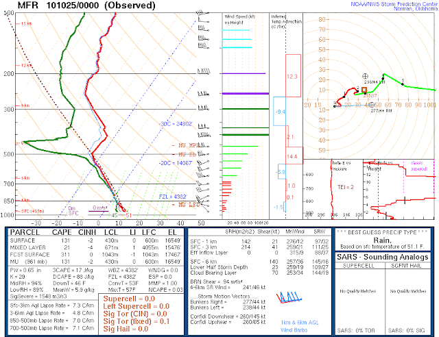
And the sounding for MFR:
167 knots or 86 m s-1! And there was still wind data all the way to 7 hPa! These speeds are not too much higher than this morning with 157 and 149 knots at SLE and MFR.
Upon further reflection though, October 500 hPa temperatures at -25 C seem a little extreme. And thats not even in the core of the extratropical cyclone! Maybe it will come ashore tomorrow near UIL.
Portland has thunderstorms in the forecast and there is lightning along the coast.
I will have to dig into how extreme these temperatures are for the Pacific Coast in October.
UPDATE: 195 knots from MFR this morning!


Steve C and I had been watching the moisture-channel manifestation of this upper jet for a few days prior, and its appearance was impressive--a firehose! I wasn't surprised to see the 150+ kt winds out of MFR once the jet reached our RAOB network. I was surprised that the balloon signal still could be picked up at MFR at 7 mb after it had been blasted so far E by those upper-tropospheric winds.
ReplyDelete